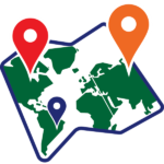
Students create a compelling interactive map that demonstrates how human and physical geography intersect. The topic can be global, national, regional, or local. The map has markers that, when clicked, provide facts about a location. Map skills lesson plans in TechnoMap are a great way to explore and learn about an area or issue.
Zoomable Map Project for Grades 6-12
Students create an interactive or zoomable map with PowerPoint or Google Slides. When the viewer clicks specific spots on the map, additional pictures and facts about the location appear. Integrate the project with any topic of study: environmental awareness, historical events, natural resources, tourist attractions, local hotspots, and more!
Integrate Map Making into a Geography, History, or Social Studies Unit
Assign meaningful and authentic challenges to engage student interest for ages 11-18. Challenge students with real-world scenarios, turning map skills into a hands-on adventure that also promotes computer skills. Technology integration ideas include: exploring a historical event, celebrating regional differences, expressing national pride, promoting environmental awareness, highlighting tourist attractions, and more!
Easy Teaching With Hassle-Free Resources
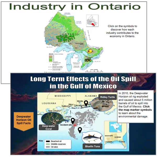
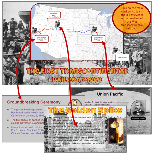
Teacher Guide is loaded with lesson plans, practical strategies, learning objectives, and assessment tools. Resource files include templates and samples of completed interactive maps to inspire and guide. Students examine the Oil Spill Effects, Transcontinental Railroad, and Industry in Ontario samples with guided questions to prepare for their own inquiry. A checklist, marking sheet, and skill summary make evaluation simple.
Differentiated Instruction Course for 21st Century Learners
Curriculum is flexible and supports a variety of learning styles. Appeal to students of differing readiness levels. Use strategies suggested in the Teacher Guide to provide reinforcement when needed. Customize assessment files. Allow independent workers to advance at their own pace. Step-by-step instructions include images for visual learners. Checklists build organizational skills and self-sufficiency. Turn map skills into a journey of discovery and fun!
Map skills lessons plans show how to create an interactive map that explores how human and physical geography intersect. The map can be of the world, country, province or state, region, or a city. Select a topic based on an area of study within geography, history, or social studies curriculum. The map could be about people and places, historical exploration, current events, environmental awareness, tourist attractions, or national pride.
Assignment 1 What is an Interactive Map?
Examine interactive maps. Contemplate how they connect geography to human activity.
Assignment 2 Brainstorm a Topic for your Map
Study research suggestions. Specify a question for investigation using an inquiry-based approach.
Assignment 3 Organize Research Findings
Investigate the topic. Document the information and location of facts using an organizer.
Assignment 4 Create the Map Slide
Design a map slide with a title and a suitable map of the area.
Assignment 5 Create Information Slides
Produce information slides that contain interesting facts about a location.
Assignment 6 Connect Slides in Interactive Map
Connect markers on the map to information slides. Control slide advancement.
Assignment 7 Interactive Map Checklist
Assess the navigation, content, and design of the interactive map. Solve any issues.
Assignment 8 Share the Interactive Map
Display the interactive map as a digital trip, map exhibit, or string map.
Optional Map Skills Lesson Plans
Screen Capture a Road Map: Save a picture of a road map.
Image Workshop: Discover multiple methods to insert images onto slides.
Organize Facts using a Table: Summarize information. Create a comparison.
Insert a Link: Insert a hyperlink that links to a website about the topic.
Map Skills Activities for Kids Explore the Interaction Between Human and Physical Geography
Design an interactive map with markers that highlight important areas using Google Slides or PowerPoint. Mapping activities encourage students to form connections between people and places. They can explain the importance of a site, describe changes in an area, report news, express civic or national pride, or highlight happenings around the world. Integrate technology with map skills lesson plans. Teaching map skills is easy with TechnoMap technology project.
Identify a topic area for inquiry
Use technology to investigate a research question
Explain the importance of an area
Create an interactive map
Form connections between human activity and geography
Select a suitable slide layout
Design informative slides with text, images, and backgrounds
Every course includes a schedule. It lists the time recommended for each assignment. Typically, it takes between 30-60 minutes to complete an assignment depending on the grade level. Based on this time frame, a typical course takes between 360-600 minutes to complete. This is about 6-8 weeks if your students have computer class twice a week. However, if your students have computer class every day, a course can be completed in about 2-3 weeks.
How do I decide which assignments to teach?
You may not have the time to teach an entire TechnoKids course. The good news is that TechnoKids offers flexibility. Many courses can be shortened by omitting assignments or lengthened by including skill reviews and extension activities. You can easily adapt the course to suit your schedule. Refer to the Ideas for Implementation section in the teacher guide for suggestions.
Does the course integrate into other subjects?
TechnoKids courses are inter-disciplinary. This means the lesson plans blend computing skills with general content areas such as language arts, geography, or business studies. If you do not have a dedicated digital literacy class, refer to the Technology Integration Suggestions section in each teacher guide for ideas on how you can include the course in other subject areas.
Is the course a subscription?
Yes. When you purchase a course, you have access to the instructional materials for 12 months. After that time, should you want to continue, you will need to renew the subscription.
Is the course online?
Yes. You must sign into TechnoHub to access the course content from your bookshelf. The teacher guide and student workbook for a course are available online only. However, resources such as assessment tools, handouts, course slides, templates, and samples are downloadable.
💬
Please fill out the form below and we will get back to you as soon as possible.


technokids.com –
technokids.com –