
TechnoMap is the second in the ‘just released’ introductory series of Google Apps for Education projects. Responding to the increasingly popular use of the free productivity tools provided by Google Apps, TechnoKids Inc. is piloting a series of projects for primary, junior, and middle school grades. These projects will use Google Docs, Google Slides, Google Sheets, and Google Forms. For schools using Microsoft Office, TechnoMap is available in a version for PowerPoint as well.
Use Google Slides for Map Making
In TechnoMap, students create an interactive map. The map has markers that, when clicked, provide facts about a location. The map can represent a geographical, historical, cultural, or even environmental topic.
Technology Integration
TechnoMap can be integrated into the Social Studies, Geography, History, or Science curriculum. An interactive map is a great way to explore and learn about an area or issue. The topic can be global, national, provincial, state, regional, or local.
Some suggested maps are:
- People and Places – Explain how land influences human activity. Map the use of natural resources, industry, or recreation in an area.
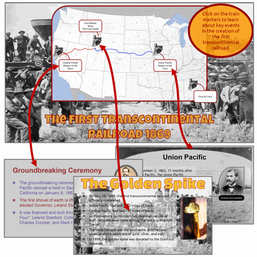
- Historical Exploration – Explore a time period or event in history. Map the location and detail the importance of historical battles, treaties, and exploration routes.
- Celebrate Differences – Pinpoint what makes an area unique. Map each region and explain what makes it different.
- Current Events – Report what is happening around the world, across the country, or in your own home town. Map the site of each event and provide the facts.
- National Pride – Express why you love your country or city. Use cultural symbols to identify sites, events, landforms, or other locations that make it a great place to live.
- Environmental Awareness – Investigate an environmental issue. Map the impact it has had on an area.
- Tourist Attractions – Plan a trip or highlight reasons to visit an area. Map places that tourists will want to see.
- Label It – Label parts of a map. Provide facts and pictures about each location.
Design an Interactive Map
To start, students study sample maps. Next, using an inquiry-based approach students select a research question to investigate. They are then guided through creating slides to make a clickable map using Google Slides. Links are created to provide factual information related to the map markers. Upon completion, the interactive map is shared with others using Google Drive and viewers are invited to comment.
Innovative Solutions
Educators facing limited budgets are looking for creative ideas. Twenty-first century technology skills must be taught, but computer resources are costly. One solution is to save on the cost of updating expensive software. Google Apps for Education is the answer for many schools. TechnoKids’ new projects – TechnoQuestionnaire, TechnoMap, and TechnoTimeline – give these teachers the tools they need to teach essential curriculum and computer skills.